Grenoble

Grenoble is a lively city in the northern French Alps. A city with a population of over 400,000 in the Grenoble area and with a large amount of research industry as well as huge student population.
For the best way to see the city and the mountains, take the teleferique or walk up to the Fort de la Bastille that over looks the city. If you are feeling really energetic, then there is also a road from La Tronche which is mentioned in the Hidden Cycling Gems section.
Grenoble is also home to a number of good museums, with the best including the Musee de Grenoble and the Musee Dauphinois.
Situated in the south-east of France, Grenoble is 560km from Paris, 100km from Lyon and 280km from Marseille. Italy is easily accessible through the Tunnel du Frejus or from the mountain town of Briancon, just over 100km east of Grenoble.

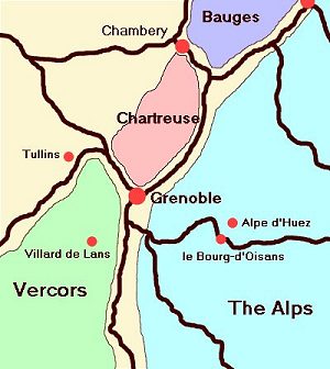
The following map ilustrates the location of Grenoble, nestled amongst the mountain ranges of the Chartreuse, Vercors and the Alps.
Average Temperatures and Rainfall in Grenoble
The following two images illustrate the average maximum and minimum temperatures in Grenoble in the years 2003, 2004 and 2005. Remember that 2003 was an exceptional year when the heatwave hit France and thousands of people died in the relentless heat that summer. You can see how hot you can expect it to be in the heat of the day and how cold it will be in the early morning from these two graphs.


The next image illustrates the average monthly rainfall in 2003, 2004 and 2005, which may help in helping you decide when to visit.

Getting out of the city is easy with numerous cycle tracks that follow alongside the rivers of the Isere and the Drac from the city centre. A map of the cycle tracks can be picked up from the station or the Grenoble tourist office.
The northern cycle track takes you 16km in the direction of Chambery and allows you to join smaller roads near Crolles. In the direction of Lyon, you can follow the cycle track for 25km which allows you safe access to the Vercors and the flatter roads west of the Alps. The southern track will take you as far as the southern most point of Grenoble near Pont de Claix.
;)
Situated along the north bank of the Isere, the St Laurent area of town offers a cyclists dream, over 20 pizzerias in 300m. I personally recommend the Pizzeria Rotolo, which is halfway along the road.
;)
Grenoble has various cycle shops around the city, especially on the road from Grenoble centre to the suburb of Gieres. There are two in St Martin de Heres. My favourite is Pinsello, in St-Martin-le-Vinoux, near to the town centre.
Also remember the Grenoble Photo Page on the site.
![]()
